Dr. Dipwad
Experienced
Also, for the pet-lovers in quarantine out there:

...and...

...and...

I’m astonished this thread wasn’t killed a hundred pages ago. It went off topic, never came back, and hasn’t changed a thing.
Let it die already.
200,000 N95 masks manufactured in China at the 3M factory, bought by the Berlin Police Force (and already paid), have been confiscated by the US government at the Bangkok Airport
The US owned 3M has been prohibited from exporting its medical products to other countries under a Korean-War-era law.
If you're posting info purporting to factual (no diss on the above), PLEASE include a link to the original source, so people can draw their own conclusions.Latest numbers:
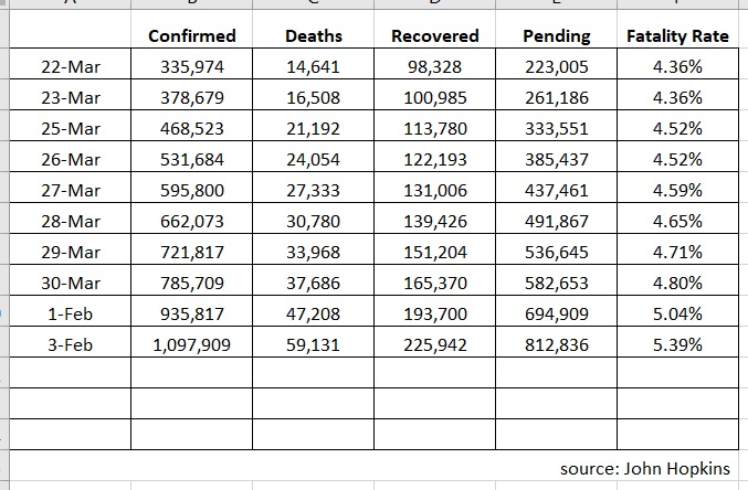
This has a daily deaths graph, data table, and growth factor numbers.My bad. I created the spreadsheet with the intention of tracking it daily.
Seems I need to take a day off now and then from numbers.
I've tried finding a back dated chart(s) from them but no luck.
This has a daily deaths graph, data table, and growth factor numbers.
https://www.worldometers.info/coronavirus/coronavirus-death-toll/
I can't speak for anyone else, but I'm not planning to come at you, provided you do all of those things relatively alone, and practice all the usual civilized social norms (e.g. washing hands on entering a space, not flicking boogers at nearby pedestrians, etc.).I’m still not shook. Going to the store and for a Mountain bike ride today. Also moved rehearsal studio to a new location yesterday that is more easily fortified. Come at me bro!


200,000 N95 masks manufactured in China at the 3M factory, bought by the Berlin Police Force (and already paid), have been confiscated by the US government at the Bangkok Airport
The US owned 3M has been prohibited from exporting its medical products to other countries under a Korean-War-era law.
Berlin's interior minister said the diversion of masks amounted to an "act of modern piracy", "Inhumane and Unacceptable", urging the US administration to adhere to international trading rules.
https://berlinspectator.com/2020/04...ump-for-confiscating-masks-bought-for-police/
https://www.bbc.com/news/world-52161995
Yeah, I saw that map, and I also noticed it didn't remove trips to the grocery store; i.e., necessities.
Everyone should read this article. (IMHO)
These Coronavirus Exposures Might Be the Most Dangerous
"The importance of viral dose is being overlooked in discussions of the coronavirus. As with any other poison, viruses are usually more dangerous in larger amounts. Small initial exposures tend to lead to mild or asymptomatic infections, while larger doses can be lethal."
https://ca.yahoo.com/news/coronavirus-exposures-might-most-dangerous-184640808.html
Convenience Store is the worst place you can possibly go... hundreds of visitors an hour.Had to go out today and was pretty surprised to see just how many people were wearing masks/scarves/bandanas.
I expected some but if anything, the people not wearing anything looked out of place at the strip mall and
gas/convenience store I stopped at.
At least around here, people are taking the CDC mask suggestion pretty seriously.