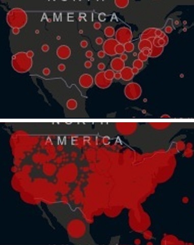
There we go with the scary red blobs again. Here, lemme zoom into my home state so you can see a more realistic representation of the number of cases:
West Virginia currently has 145 confirmed cases. But JHU’s map would lead you to believe ever person in the state has it.
You can't fight what you can't see. It's easier to "see" the virus in a small USA rural town IF you have adequate testing, which we don't. Without adequate testing and targeted stay-at-home, the fallback position is massive stay-at-home. The next fallback is full quarantine.
Many rural areas are already part of the first fallback: massive stay-at-home. A key problem with that is local health systems are sized to population whether 2,000 or 2,000,000. That means without adequate testing rural towns will likely become miniature New Yorks because they're hunting the virus blind and ratio of beds to people I'm guessing is similar. Factor in local ages, health, funding health of those small hospitals, their position in priority list for supplies and ventilators...it can add up to near, same or worse than NY on a miniature scale.
What is disturbing about the map of your home state is the
distribution of red dots. Probably the smartest thing to do to save small towns in rural USA is what they did in China: full quarantine, no one in, no one out except core essentials.
In the USA however there is a huge problem with quarantine --
the distribution of the red dots. Quarantine, the last fallback position, doesn't work if there are red dots outside the quarantine.
We blew our opportunity to hunt the virus and fence it in with targeted stay-at-home. Then we blew our opportunity for
early fallback to stay-at-home. Add those two up and we've already blown our opportunity for the last fallback position of quarantine.
If this were a military theatre, the first generals would be gone, and we'd be well into firing the second set of generals.